Understanding Relative Motion

A few weeks back, in a discussion regarding the effectiveness of whether ’tis better to alter course for large cargo ships far in advance, or to proceed boldly ahead until the ColRegs take hold, I noted that relative motion diagrams are not all that commonly understood. Whilst most will not have occasion to whip out a maneuvering board and hand-draw a plot, understanding relative motion is still a key part of interpreting motion on a radar screen.

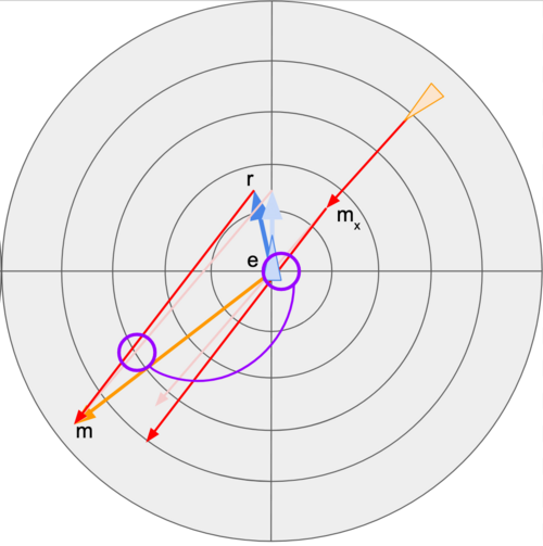
Here is my initial attempt at a short slide deck explaining the basics of relative motion and how to use that in evaluating crossing situations at sea:

https://docs.google.com/presentation/d/1-zx4r2QvN90tAFsvS3CJqxFO6LRbtmoMk3baTVetLgc/edit?usp=sharing

A Bit of Nautical Trivia

When I first began sailing I heard a tale that the US practice of placing the red buoys to the starboard side of channels, a reversal to the current practice in Europe and elsewhere, came about as an attempt to trick the English during the American Revolutionary War. In a true hallmark of an urban legend, I later ran across similar stories, with only the war replaced.

A vessel outbound in the San Francisco Main Shipping Channel

I therefore present what I consider a correct answer to “what’s with the Americans?”, as well as the origin of the starboard tack rule. In short, the Americans were not simply being contrary, and the starboard tack rule is relatively recent (if relatively, to you, encompasses the 18th century). Onwards…

Continue reading

Satellite Messengers: Deciphering Reliability

Read any discussion about emergency beacons in the wilderness and you’ll see a common set of claims. People will point out how one device is more reliable than another, list examples of messages that failed to send (or eventually were sent after a long delay), and a few are sure to chime in about how PLBs are the ultimate in reliability.

I have my own preferences, of course, and like to ensure my perceptions are grounded in reasonable fact. There have been a few technological improvements over the years, as well as a few details not immediately apparent at first glance. I can, for example, discuss the advantages of the Iridium network over the GlobalStar design, but is that really why users of one network might see greater reliability?

Continue reading

Electronic Navigation Tips

As NOAA recently announced their decision to sunset raster chart production over the next 5 years, some may find this useful.

Many people are familiar with using apps such as Navionics for basic navigation.  To me, the functionality of such apps is often severely limited, almost more a toy than a serious tool.  That needn’t be the case.

Instead, I’d like to present some options for effective electronic navigation.  The challenge here is finding applications that support them, of which there are few.  My preference is an app called SEAiq; it has an enterprise version with even greater functionality, but we’ll stick with the more affordable recreational version for now.

SEAiq has a few particular tools that are quite useful:  the ability to create electronic bearing lines (EBLs), variable range markers (VRMs), mariner’s notes, and course vectors for both your own ship and for AIS targets.  Some of these can also be combined, for example you can attach a VRM to an AIS target.

Continue reading